Hurricane Florence: U-M researchers forecast impacts
More than 2 million people could lose power, and flooding is the major concern for several reasons.

More than 2 million people could lose power, and flooding is the major concern for several reasons.
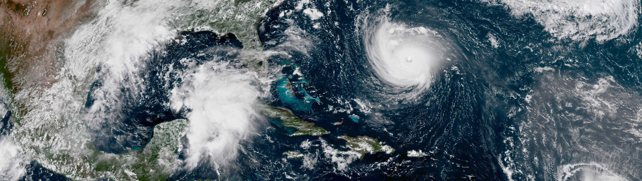
As Hurricane Florence approaches the East Coast, Michigan Engineering experts are producing important forecasts and discussing the storm’s potential impacts and its relationship to climate change.
The storm models suggest that as the storm approaches land, it will slow down and the path will become more uncertain, said Richard Rood, professor of climate and space sciences and engineering and Weather Underground blogger.
“It’s like a basketball free throw that hits the rim—initially, the trajectory was direct and well defined, but after it hits the rim it rattles around,” he said. “That makes the storm more dangerous as it stalls and rain drenches the region.
“Storms of this magnitude are rare this far north,” he added. “As compared to the past, more precipitation is likely, sea level is higher, and storm surge could be significantly higher. There is evidence that storms are more likely to stall and move slowly. The potential for peril is extraordinary at both the coast and inland.”
The storm’s stall on the coast is just one reason flooding is a major concern, explains Perry Samson, an Arthur F. Thurnau Professor of climate and space sciences and engineering, in this video update to the “Hurricanes: What’s Next?” MOOC he taught earlier this year.
“Soil moisture maps show that the ground is not dry. It doesn’t have a lot of capacity to absorb more precipitation,” Samson said. “And on top of that, if you look at stream flow, it’s at 90 percent of capacity in a lot of places inland in North Carolina and Virginia. So as the storm moves inland, we have great potential for flooding there as well.
“Much like Matthew a few years ago, the storm surge, and the high winds are an issue, but it’s more the precipitation and the flooding that are going to be the greatest concern in this case.
“Tides will be high at noon and midnight and that will be the worst time for storm surge.”
More than 2 million people are expected to lose power, according to Seth Guikema, associate professor of industrial and operations engineering, and civil and environmental engineering.
Guikema and his colleagues have generated a power outage forecast that they will update regularly. As of 1 p.m. ET Sept. 11, they estimated that 2.4 million people would be without power (View the current forecast). The forecast takes into account several different measures of wind speed and how the wind could affect trees, as well as the storm path and the population density by census tract.
“We expect to see a large number of outages in North Carolina with the most intense outages along the coast as expected,” he said. “However, we expect to see more scattered outages extending a considerable distance inland as well as into South Carolina and Virginia. Residents of the area should prepare for a prolonged period without power.”

In the Climate and Space Research Building, researchers are monitoring Florence’s intensification in the CYGNSS Science Operations Center. NASA’s CYGNSS, or Cyclone Global Navigation Satellite System, is a constellation of eight microsatellite observatories that track storm intensification in unprecedented detail. Today, this process is not well understood and storms are expected to increase in intensity due to climate change. CYGNSS tracks wind speed data at tropical hurricane latitudes across the globe, taking 32 measurements per second. Read more about CYGNSS.
Warmer than normal sea surface temperatures serve to drive faster development of more intense storms,” said Jonathan Overpeck, dean of the School for Environment and Sustainability and a professor of climate and space sciences and engineering.
“Hurricane Florence has developed into yet another poster child for how human-driven climate change is supercharging tropical storms and their impacts,” he said.
“Our warming atmosphere allows the air and storms to hold more water, increasing the risk of more intense rainfall. These factors, plus the clear rise in sea level that is already significant and ongoing, means more likely wind damage and flooding than in the past.
“Continued burning of fossil fuels and greenhouse gas emissions will mean more risk from devastating tropical storms and hurricanes in the future.”


